 EMODnet Product Catalogue
Dissolved gases
Type of resources
Available actions
Topics
Keywords
Contact for the resource
Provided by
Years
Formats
Representation types
Resolution
-
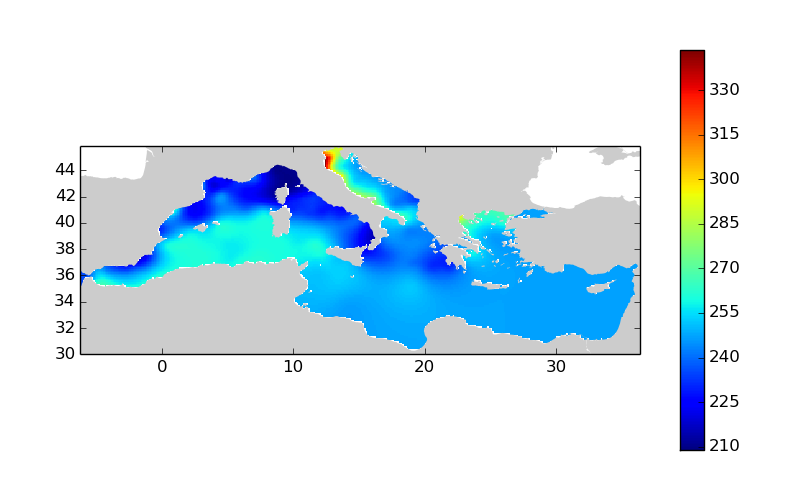
Moving 10-years analysis of dissolved_oxygen_concentration at Mediterranean Sea for each season : - winter (January-March), - spring (April-June), - summer (July-September), - autumn (October-December). Every year of the time dimension corresponds to the 10-year centered average of each season. Decades span from 1971-1980 until 2006-2015. Observational data span from 1911 to 2015. Depth range (IODE standard depths):-3000.0, -2500.0, -2000.0, -1750.0, -1500.0, -1400.0, -1300.0, -1200.0, -1100.0, -1000.0, -900.0, -800.0, -700.0, -600.0, -500.0, -400.0, -300.0, -250.0, -200.0, -150.0, -125.0, -100.0, -75.0, -50.0, -30.0, -20.0, -10.0, -5.0, -0.0. Data Sources: observational data from SeaDataNet/EMODNet Chemistry Data Network. Description of DIVA analysis: Geostatistical data analysis by DIVA (Data-Interpolating Variational Analysis) tool. Profiles were interpolated at standard depths using weighted parabolic interpolation algorithm (Reiniger and Ross, 1968). GEBCO 1min topography is used for the contouring preparation. Analyzed filed masked using relative error threshold 0.3 and 0.5. DIVA settings: A constant value for signal-to-noise ratio was used equal to 1. Correlation length was optimized and filtered vertically and a seasonally-averaged profile was used. Logarithmic transformation applied to the data prior to the analysis. Background field: the data mean value is subtracted from the data. Detrending of data: no. Advection constraint applied: no. Originators of Italian data sets-List of contributors: o Brunetti Fabio (OGS) o Cardin Vanessa, Bensi Manuel doi:10.6092/36728450-4296-4e6a-967d-d5b6da55f306 o Cardin Vanessa, Bensi Manuel, Ursella Laura, Siena Giuseppe doi:10.6092/f8e6d18e-f877-4aa5-a983-a03b06ccb987 o Cataletto Bruno (OGS) o Cinzia Comici Cinzia (OGS) o Civitarese Giuseppe (OGS) o DeVittor Cinzia (OGS) o Giani Michele (OGS) o Kovacevic Vedrana (OGS) o Mosetti Renzo (OGS) o Solidoro C.,Beran A.,Cataletto B.,Celussi M.,Cibic T.,Comici C.,Del Negro P.,De Vittor C.,Minocci M.,Monti M.,Fabbro C.,Falconi C.,Franzo A.,Libralato S.,Lipizer M.,Negussanti J.S.,Russel H.,Valli G., doi:10.6092/e5518899-b914-43b0-8139-023718aa63f5 o Celio Massimo (ARPA FVG) o Malaguti Antonella (ENEA) o Fonda Umani Serena (UNITS) o Bignami Francesco (ISAC/CNR) o Boldrini Alfredo (ISMAR/CNR) o Marini Mauro (ISMAR/CNR) o Miserocchi Stefano (ISMAR/CNR) o Zaccone Renata (IAMC/CNR) o Lavezza, R., Dubroca, L. F. C., Ludicone, D., Kress, N., Herut, B., Civitarese, G., Cruzado, A., Lefèvre, D., Souvermezoglou, E., Yilmaz, A., Tugrul, S., and Ribera d'Alcala, M.: Compilation of quality controlled nutrient profiles from the Mediterranean Sea, doi:10.1594/PANGAEA.771907, 2011. Units: umol/l
-
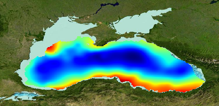
Gridded product for visualization of Water body dissolved oxygen concentration in the Black Sea generated by DIVA 4.6.11 using all EMODNET Chemistry data from 1970 to 2014. Depth range (IODE standard depths): 0 – 250m. DIVA settings: signal-to-noise ratio and correlation length were estimated using data mean distance as a minimum (for L), and both parameters vertically filtered. Background field: the data mean value is subtracted from the data. Detrending of data: no. Advection constraint applied: no. Every year of the time dimension corresponds to a 10-year centred average for each season: - winter: December - February, - spring: March - May, - summer: June - August, - autumn: September – November Units: umol/l
-
EMODnet Chemistry aims to provide access to marine chemistry datasets and derived data products concerning eutrophication, acidity and contaminants. The importance of the selected substances and other parameters relates to the Marine Strategy Framework Directive (MSFD). This aggregated dataset contains all unrestricted EMODnet Chemistry data profiles on eutrophication and acidity, and covers: the Artic Ocean, the North East Atlantic, the Greater North Sea and Celtic Seas, the Baltic Sea, the Mediterranean Sea and the Black Sea. ITS-90 water temperature and water body salinity variables have also been included ('as are') to complete the eutrophication and acidity data. If you use these variables for calculations, please refer to SeaDataNet for the quality flags: https://www.seadatanet.org/Products/Aggregated-datasets. This European dataset is the result of the aggregation of the regional datasets concerning eutrophication and acidity present in EMODnet Chemistry. The regional datasets are automatically harvested, and the resulting collections are aggregated and quality controlled using ODV Software and following a common methodology for all sea regions ( https://doi.org/10.13120/8xm0-5m67). Parameter names are based on P35 vocabulary, which relates to EMODnet Chemistry aggregated parameter names and is available at: https://vocab.nerc.ac.uk/search_nvs/P35/. This process were regionally performed by: 'Institute of Marine Research - Norwegian Marine Data Centre (NMD)' (Norway), 'IFREMER / IDM / SISMER - Scientific Information Systems for the SEA' (France), 'Aarhus University, Department of Bioscience, Marine Ecology Roskilde' (Denmark), 'Swedish Meteorological and Hydrological Institute (SMHI)' (Sweden), 'Hellenic Centre for Marine Research, Hellenic National Oceanographic Data Centre (HCMR/HNODC)' (Greece) and 'National Institute for Marine Research and Development 'Grigore Antipa' (Romania). When not present in original data, water body nitrate plus nitrite was calculated by summing all nitrate and nitrite parameters. The same procedure was applied for water body dissolved inorganic nitrogen (DIN), which was calculated by summing all nitrate, nitrite, and ammonium parameters. Concentrations per unit mass were converted to a unit volume using a constant density of 1.25 kg/L. The aggregated dataset can be downloaded as an ODV collection.
-
CTD measurements as a part of observation plan in the coastal area near Mersrags were performed within the project "AQUAFIMA – Integrating Aquaculture and Fisheries Management towards a sustainable regional development in the Baltic Sea Region". Observations were made at a potential fish spawning and nursing site in the coastal area of the Gulf of Riga in August 2013.
-
The investigations of Blekinge coast started in 1978. In 1990 the program "Blekinge Kustvattenkontrollprogram" Blekinge Coastal water control programme, was formed, building on the stations sampled earlier, but with extended sampling.
-
Memorial University has over the past 15 years been involved in various ocean glider activities with deployments focused primarily on the Newfoundland Shelf and the Labrador Sea. For example, there are four deployments with glider data in the Labrador Sea. Partnerships with Fisheries and Oceans Canada and Ocean Gliders Canada have also resulted in deployments of Memorial's gliders in the Pacific. The data contain 14’663 mission kms, 620 deployment days and 25’108 individual glider profiles. L1 NETCDF files for every deployment archived on the Memorial University’s Glider Data server are made available publicly for scientific research. Deployments vary in duration and region. All files were processed with the SOCIB glider toolbox ((Troupin et al., 2015)-[https://doi.org/10.1016/j.mio.2016.01.001]), modified by Nicolai von Oppeln-Bronikowski, 2019 for MUN glider deployments. Metadata: File creator(s), contact info, institution, applicable funding, responsible researcher(s), deployment region, deployment start, deployment end, longitude min, longitude max, latitude min, latitude max, glider type, glider configuration if known, sensors, sensor serial numbers, science data QC. Glider Data: Minimum Data: Time, Depth, Position, Depth-Averaged Current, CTD. Most Deployments: Oxy_umolL, Oxy_Calphase_DEG, Oxy_sat Some Deployments: pCO2_uatm, pCO2_Calphase_DEG, pCO2_Dphase Important Note: This submission has been initially submitted to SEA scieNtific Open data Edition (SEANOE) publication service and received the recorded DOI. The metadata elements have been further processed (refined) in EMODnet Ingestion Service in order to conform with the Data Submission Service specifications.
-
The East Sea Real-time Ocean Buoy (ESROB) is a surface mooring that has been in operation off the mid-east coast of Korea since 1999. The ESROB is 9 km off the coast (37° 32.24’N; 129° 12.92’E) in a water depth of 130 m, and provides meteorological and oceanographic (physical and biogeochemical) data every 10 min from Conductivity-Temperature-Depth (CTD) and acoustic Doppler current profiler (ADCP) instruments. The data provided here were collected between 2016 and 2020 and follow the data collected by previous publications. The data were quality controlled and assured using typical data processing methods, and have been used to address temporal variations in currents and water properties, as well as wind-and tide-induced internal waves. The uploaded data files contain variables in a NetCDF format that were obtained during each deployment. Important Note: This submission has been initially submitted to SEA scieNtific Open data Edition (SEANOE) publication service and received the recorded DOI. The metadata elements have been further processed (refined) in EMODnet Ingestion Service in order to conform with the Data Submission Service specifications.
-
The datasets contains selected data from the underwater glider missions in Eastern Mediterranean performed in April-May and in August 2023 by Institute of Marine Sciences, Middle East Technical University (METU-IMS). The glider was donated to METU-IMS by Is Bankasi - the national commercial bank in Turkey. The underwater glider SeaExplorer X2 of ALSEAMAR is equipped with the following instruments: 1) RBRlegato³ C.T.D (non-pumped flow) with temperature, conductivity and pressure sensors; 2) JFE Advantech Co. Rinko Fast Optical DO sensor; 3) Wet Labs ECO Puck (fluorescence and turbidity); 4) Sea-Bird Scientific Deep SUNA Ocean Nitrate Sensor; 5) Altimeter. The research area is between mainland and Cyprus bounded by a rectangle with coordinates 35.52°-36.1°N, 33.2°-33.5°E. The first mission with internal number 16 was carried out in period April, 26 – May, 16, 2023, the second mission with internal number 20 was carried out in period August, 2 – August, 27, 2023. The first and last transects from each mission are included in the dataset. The dataset is submitted as zip-archive containing 110 .gz files. Each .gz file contains instrument output acquired within one glider dive cycle.
-
All major businesses that have a discharge point into water and according to the Environmental Code are classified as environmentally hazardous are also responsible for taking samples of the water they discharge themselves. Such a business can, for example, be an industry, a sewage treatment plant or a large farm. Since the water that a discharge point empties into is called a recipient, this sampling is called recipient control. The municipality conducts water quality sampling at all discharge points from the treatment plants. Through this sampling, we measure, among other things, depth of view, oxygen content, levels of nutrients and more. The purpose of the investigation is to describe and monitor the environmental impact on the recipient from Osthamar's treatment plant and urban area.
-
Repeat hydrography, as organized through the GO-SHIP network, is fundamental for detecting trends and variability also in the Mediterranean Sea. The Mediterranean component of GO-SHIP is MedSHIP, and TAlPro is the western Mediterranean component. The TAlPro2022 cruise consisted of 26 full depth hydrographic stations crossing the Tyrrhenian Sea from north to south, then the Algero-Provencal Basin from south to north. Here the postcalibrated bottle file data are made availiable. Postcalibration has been done by measuring dissolved oxygen and salinity on water samples collected by the rosette. The dataset contains also all chemical variables, measured in the lab.